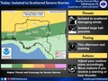
Rain-cooled and stable air has brought an end to the tornado/severe threat for many for this evening
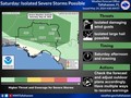
May 13 - 4:15pm ET Update - Rain-cooled and stable air has brought an end to the tornado/severe threat for many for this evening.
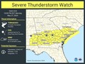
We're still watching some areas across the coastal areas of the Apalachee Bay and the southeast Big Bend for a severe threat. The image below has the updated tornado watch. There will still be heavy rain through the afternoon hours but we'll likely see a lull in the activity for much of the evening and hours. Activity likely picks up sometime overnight from the west but more information about that will come later this evening.
In the meantime there will be some brief periods of gusty 30 to 45 mph wind gusts behind all this activity through the next 2 to 3 hours, but these will subside into the evening as well.
#FLwx #GAwx #ALwx


|
|
Weather searching weather forecast for all cities in the world.
The second option is to search through list of continents and countries.
