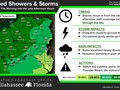
Multiple rounds of showers and thunderstorms are in the forecast the next couple of days
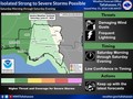
Multiple rounds of showers and thunderstorms are in the forecast the next couple of days (Monday, May 13th and Tuesday, May 14th). Unfortunately, there is the potential for some of the thunderstorms to be strong to severe, including the potential for damaging wind gusts, hail, and a few tornadoes. The first round of storms could impact the western parts of the area as early as Monday morning before spreading east as the day progresses. Another round is possible late Monday night into Tuesday.
In addition to the threat for strong to severe thunderstorms, there is also the potential for locally heavy rain that could cause flash flooding. Widespread rainfall amounts of 2 to 5 inches of rain is currently forecast. However, there is the potential for locally higher amounts of 8"+. As a result, a Flood Watch has been issued for much of the area. Now is a good time to make sure storm drains are clear of any debris.
Be sure to have ways to stay updated with the latest forecast over the next couple of days and have a way to get warnings should they be issued.


|
|
Weather searching weather forecast for all cities in the world.
The second option is to search through list of continents and countries.
